


les Fours a partir de Valezan

franquen
User
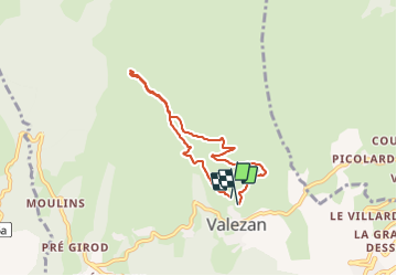

Length
6.2 km

Max alt
1590 m

Uphill gradient
331 m
Km-Effort
10.6 km

Min alt
1251 m

Downhill gradient
333 m
Boucle
Yes
Creation date :
2022-01-06 10:28:09.574
Updated on :
2022-01-06 12:45:10.834
2h11
Difficulty : Medium

FREE GPS app for hiking
 SityTrail
IGN / Geographical institutes
SityTrail Plus
The world is yours!
About
Trail Walking of 6.2 km to be discovered at Auvergne-Rhône-Alpes, Savoy, La Plagne-Tarentaise. This trail is proposed by franquen.
Positioning
Country:
France
Region :
Auvergne-Rhône-Alpes
Department/Province :
Savoy
Municipality :
La Plagne-Tarentaise
Location:
Unknown
Start:(Dec)
Start:(UTM)
319979 ; 5049797 (32T) N.
Comments